Unique map of Venetian Crete acquired in auction
A beautiful hand-drawn map of the siege of Candia (Herakleion) by the Ottomans in 1669, was recently bought in auction thanks to the generosity of the Overseers of the Gennadeion.
This exquisite bird’s eye view complements the unique collection of maps of the island of Crete at the Gennadius Library that include hand-drawn versions of the maps published by Boschini as well as other drawings that may have been made by the Italian cartographer and military engineer Francesco Basilicata (died c. 1640), who spent several years in Crete, in the service of the Venetian Republic.
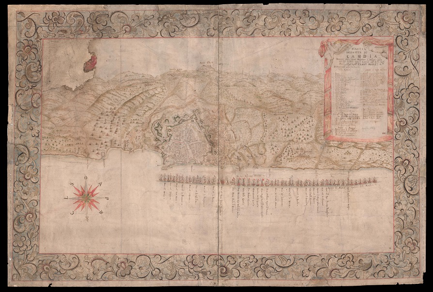
The map is entitled: “Piantta della Città di Candia, attacata dalle Armi Ottomane e diffesa dalla S(erenissim)a R(epubbli)ca di Ven(ezi)a, sotto il commando dell’ Ecc(ellentissi)mo Sig(no)r Procu(rato)r e Cap(ita)n Gen(era)ll Fran(ces)co More(si)ni.”
The 25-year-long siege of Candia by the Ottomans (1645-1669), otherwise known as the Cretan War, which ended with the surrender of the city to the Turks by Francesco Morosini in 1669, was a catalyst for the production of maps meant to solicit European support to defend the cause of Venetian Crete as a last bastion of Christianity in the Eastern Mediterranean. The maps display the attacking forces with their siege machines and the trajectories of the artillery towards the walls as in this bird’s eye view of the besieged city. Dated to July 1669, two months before the surrender of the city, this plan is oriented to the south, focuses on the fortifications of the island’s capital city, Candia, and enumerates the ships of the defenders as well as the encampment of the Ottoman forces on the horizon next to Mount Ida), the so-called ‘Candia nova.’ The whole is surrounded by a broad border decorated with an elaborate and intricate design of acanthus leaves and flowers. In the lower section of the map, we see the ships of the Christian fleet; it is worth noting that the flagship of the French squadron La Thérèse is shown engulfed in flames, an event that occurred on July 24, 1669. In addition, the bastion of Sant’ Andrea (bottom right) is depicted destroyed, an event that occurred during the last phase of the siege. It should be noted that few depictions of the siege show the bastion of Ag. Andrew in this condition. In fact, the cartouche informs us that the map highlights the fortifications of Candia.
The key to the map, and a comprehensive list of the participants, both Venetian and Ottoman, appears within the curtained title cartouche upper right, held by two cherubim. The most illustrious name amongst them is the leader of the Venetian forces, Francesco Morosini (1618–1694), who as commander-in-chief of the Venetian fleet in 1667 was sent to relieve the besieged island of Crete. Within two years the city of Candia had surrendered completely to the Ottomans and Morosini had to stand trial for treason and cowardice but was acquitted, and eventually was elected doge of Venice in 1688. This map shows the last significant effort by Morosini to win back the island.