History of Corinth
Location
Corinth is located eighty kilometers west of Athens on the south side of the Isthmus, a narrow neck of land connecting the Peloponnese to mainland Greece and separating the Corinthian Gulf from the and Saronic Gulf and ultimately the Ionian and Aegean Seas. By land, traffic moving north and south was channeled into a narrow corridor. At one end of the corridor, routes fanned out to Athens and to Thebes and beyond. At the other end the routes led along the coast west towards Patras, east to Epidauros and through passes on either side of Acrocorinth to the Argolid and Arcadia. Corinth possessed four harbors. Two, Schoenus and Poseidona, were presumably fairly simple docking facilities that served either end of the Diolkos. The Diolkos was a paved portage road, probably built in the 6th century BC, across the 6 kilometer width of the Isthmus. Historical sources mention five successful and one unsuccessful attempt to portage warships over the isthmus between 428 and 30 BC. Niketas Oryphas, revealing his familiarity with ancient literature, affected a sixth crossing in AD 881. From the vulgar humor of Aristophanes’ Thesmophoriazousae 648, one can surmise that the Diolkos was regularly used for the haulage of merchant ships as well.
With water, an imposing acropolis, a large fertile coastal and a position between two seas, Corinth thus commanded the principal nodal point in the land and sea communications of southern Greece. Its strategic and commercial position was supplemented by valuable natural resources for export including building materials, excellent clays for ceramics and mortars, wood and agricultural produce. It is not so much that Corinth’s own riches were being moved, however. The importance of Corinth was as an entrepôt engaged in the movements, industry and produce of other regions.
Habitation
The area of the site excavated to date concentrates largely on the Roman Forum and its surrounds. This zone is the transition, marked by a steep 15 meter, ten to twenty percent slope, between the two terraces on which Corinth was built. Here the Peirene Valley allowed the easy transition for wheeled and pedestrian traffic between the upper and lower terraces. The upper valley is occupied by the Roman Forum and the lower valley by the Lechaion Road.
The earliest discoveries from the Forum area date to the Early Neolithic period, c. 6,500-5,750 BC. There is evidence for Mycenaean and Sub-Mycenaean activity but the establishment of a permanent settlement on the site can only be confirmed from about 3,000 years ago. Thanks to its strategic position, the settlement grew rapidly in the 8th and 7th centuries B.C. when Corinth established colonies as far away as Corfu and Syracuse in Sicily.
Geometric and Archaic Corinth
The earliest Geometric is represented by domestic debris in the valley floor, graves and a well. In the second half of the eighth century, however burial was kept separate from the residential area. At the same time the first stone architecture becomes evident and the water courses of the springs are artificially channeled. Evidence for roads survives which directed traffic from the south and southwest towards the north at the mouth of the valley.
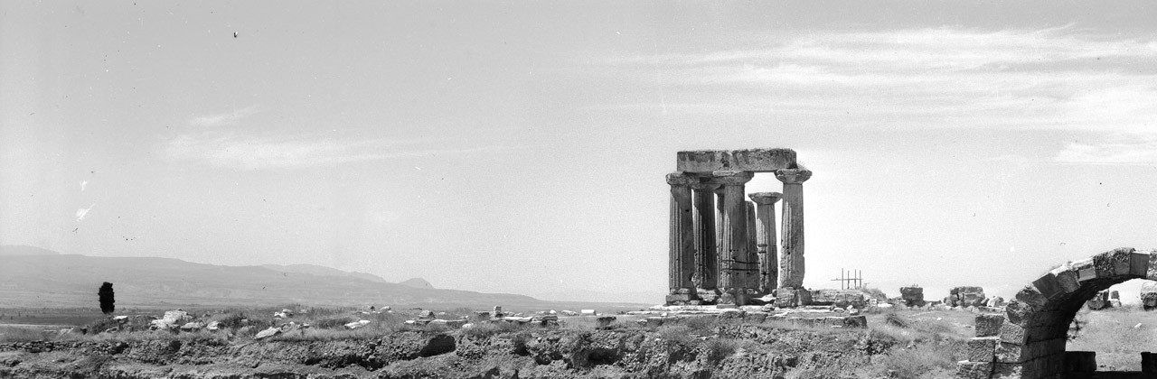
In the seventh century the first temple is built on the rise to the north of the forum. The street plan developed with the addition of roads parallel to the Geometric streets and still channeling traffic from the south and west towards the north. The Sacred Spring was elaborated and at this point perhaps first has cult associated with it. In the mid-seventh century a small house with a well was constructed to the south of the spring. In the Lechaion Road valley the Cyclopean fountain was constructed and houses also faced the road towards Acrocorinth. In the sixth and early fifth century the early temple was destroyed c. 580 to be replaced about forty years later by the Archaic temple which still stands on the site today. The formal approach was from the north east but access was supplemented by a monumental ramp up from the street which ran past the Sacred Spring to the south east. To the east of the temple at the base of the cliff separating it from the valley a small stoa was built. A cluster of proto-Geometric graves received a temenos and a small underground shrine was established alongside a new road to Acrocorinth.
Classical and Hellenistic Corinth
The later fifth and early fourth centuries saw rapid organized and formalized development that gives the impression of a thoroughly urban space. Peirene fountain receives draw basins, Temple A is constructed to the north, and the Sacred Spring is further developed with a triglyph and metope wall and curious apsidal temple. A race course more or less follows the southernmost Archaic road and the houses which flanked it are replaced by larger complexes. To the west the house of a merchant dealing in imported fish fillets is constructed and disappears and finally a bath complex is established. The main changes of the period following is a realignment of the race track and the construction of the South Stoa.
A question that has constantly arisen is the location of the Agora and many would beleive that the Corinthian agora was the predecessor of the Roman forum. This area in the Greek period, however, had a relatively steep and continuous slope from the Sacred Spring up to the South Stoa interrupted only by the race track. All the roads found to date channel traffic in a general northwards direction while the water supply also serves and supplies the area towards the north. Although it might be argued that the lack of inscriptions in the area of the forum are to be expected in a tyrannical and, later, an oligarchic form of governance as opposed to a democracy, it is notable that what inscriptions have been found concentrate at the north east side of Temple Hill. A better hypothesis, therefore, is that the agora was located immediately to the north of the excavated zone. If not an agora then what were the main functions of the excavated area of the later forum in the Classical period? This also was summarized and answered by Williams; it was largely dedicated to cult, especially non-Olympian cult, housing and minor industry. The evidence for cult includes fragments of inscriptions, buildings, temenoi, a race track and 26 hero reliefs. The cults attested tend to be of deities with local rather than pan Hellenic significance and include Hellotis celebrated with a torch race on the race track, her sister Kotyto perhaps in the Sacred Spring, Artemis Korithos, Peirene but also Poseidon, Aphrodite and perhaps Dionysos, Hermes and the nymphs. There are also heroes including Zeuxippus and unknown dead ancestors.
In 146, after defeating the Achaean League led by the Corinthians at Lefkopetros on the Isthmus, the Roman general Mummius sacked Corinth. He sold the women and children into slavery, and killed the male population. Thereafter Corinth no longer was a political entity but at best an almost deserted ghost town occupied by a small non-Corinthian population engaged in cultivation of the agricultural land. Finds identified from this interim period amount to 42 Knidian amphorae stamps, some Megarian bowls and 90 odd coins. The prestige and income from the Isthmian games devolved to Corinth’s neighbor Sikyon and the rich agricultural land was auctioned off as ager publicus every two years in Rome. The city was refounded as a colony for 16,000 colonists in 44 BC by Julius Caesar. Its territory was measured out into portions for the colonists and the city was redeveloped as an orthogonal. There is little reason to believe that many of Corinth’s religious traditions survived. Dr. Bookidis will be dealing briefly with three of the cults that were resurrected; those of Apollo, Asklepius and Demeter.
Roman Corinth
In the Earlier Roman period the Forum was a huge open space about 200 meters east-west and 100 meters north south taking its orientation from the surviving South Stoa which defined its southern edge. The South Stoa was modified converting some of its smaller spaces into larger rooms but it retained its colonnade. Dominating the skyline to the north the Archaic Temple of Apollo on Temple Hill was flanked by colonnades to the north and south. The colonists had rotated its orientation by 180 degrees to face an approach from the road out of the Forum to the west. Its interior colonnade was removed and re-erected in a line running north from the west end of the South Stoa along the road to Acrocorinth. Also, to the north was a long basilica flanking the Lechaeum road on one side with the cliff of Temple Hill on the other. The Lechaeum road, entering the Forum from the north, ascended a broad stairway through a three-bayed monumental arch. East of the Lechaeum Road Peirene had been refurbished and extended. The former simple façade of the draw basins was walled off with a series of arches. A rectangular two-storey court enclosing a rectangular pool was added to the north.
On the east side of the Forum stood the Julian basilica. At Forum level this was a cryptoporticus basement. The first storey, approached by a staircase of 14 steps up to a porch was an open rectangular space 38 by 24 meters in extent with Corinthian columns supporting a clerestorey and a marble dado. Inside were set up sculptures of the Imperial family. These include Augustus in Pentelic marble, dressed in a toga with a fold draped over his head portrayed engaged in sacrifice. He was flanked by his adopted sons Caius and Lucius Caesar portrayed in heroic nudity with a chlamys over the shoulder perhaps, appropriately, as the Dioscuroi. Clearly this building had some high civic function.
To the west of the Forum stood Temple E. This was a 6 by 11 column peripteral temple on a low base with long stoas flanking it to the north and south. The identification of the temple has been hotly debated. Some consider it to be dedicated to Jove or Zeus based on its size and location, others regard it as the Temple of Octavia. In front of the temple was a range of more typically Roman temples and monuments. Two prostyle temples, F and G, were dedicated to Venus and to Clarion Apollo respectively. Built in the Roman style, they stood on high concrete and rubble, marble clad podia approached from the east by a stair. To the north was a fountain house dedicated to Poseidon decorated with a statue of the god and dolphins and a circular monument decorated in the Corinthian order and dedicated by Gnaius Cornelius Babbius. South of center in the Forum was the rostra considered by many to be the Bema in front of which Paul was brought by the elders of the Jewish community. A second topos for those following the travels of Paul in Greece can be found East of the theatre (also remodeled to suit Roman taste). Here is the inscription “Erastus Proaedilitate Suae Pecuniae Stravit” that is more or less “Erastus, while Aedile, paid for the paving”. Since the office of Aedile can be pretty much equated with that of Economus, it is thought that this is the Economus Erastus whose greetings Paul forwards in his letter to the Romans.
A hundred years later the form of the Forum remained much the same but with additions such as the Odeion, another temple at the west end of the Forum, shops to the west of the rostra and a new basilica south of the South Stoa.
Late Antiquity
In the Late Roman period Corinth seems to have radically transformed. Earthquakes in the late 4th century and a social call by Alaric and his Goths seem to have reduced the city. It seems that the great sanctuaries of the Hellenic deities, Demeter and Asklepios, already under legislative pressure to close, did not survive. Efforts were made to refurbish the area of the Forum, however, most notably by reappointing Peirene and the west shops and by converting the central shops into the broadest stairway in the Roman world. A city wall was laid out encompassing the heart of the city in the early fifth century. Remote sensing survey suggests that this wall encompassed only about 25% of the area hitherto envisioned and clearly assertions about the relationships of cemeteries and churches to the city center will have to be revised. The sixth century saw the construction of the first buildings to be dedicated to Christian worship. A huge church, the length of two football fields, was built at Lechaion and smaller basilicas were erected at Kraneion, Skoutela and in the plain just north of the city. What should have been an auspicious time for Christian Corinth fell victim first to bubonic plague with high mortality levels and subsequently a deep economic depression that lasted, in terms of the archaeology, for 500 years. The Dark Ages started at the end of Antiquity and ended with the floruit of Byzantium.
TIMELINE
ca. 6,000 B.C. Earliest, Neolithic finds from Corinth area
ca. 1000 B.C. Beginning of continuous settlement
8th century B.C. Rule of the Bacchiads. Corinthian colonies founded in Kerkyra (Corfu) and Syracuse
Late 7th to early 6th centuries B.C. Commercial and industrial development. Corinthian pottery widespread around Mediterranean. Rule of tyrant Kypselos and his son Periander.
ca. 550 B.C. Currently visible Temple of Apollo built
431-–404 B.C. Peloponnesian War (Peace of Nikias 421–415 B.C.)
395-–387 B.C. Corinthian War
338–-243 B.C. City held by the Macedonians
243 B.C. Acrocorinth taken by the Achaian commander Aratos with 400 men
146 B.C. Corinth sacked by Mummius after ill-judged war against Rome
44 B.C. Roman colony of Laus Julia Corinthiensis founded by Julius Caesar
A.D. 52 St. Paul visits Corinth
A.D. 67 Excavation of Corinth Canal begun
2nd century A.C. Many public buildings built under patrons including Herodes Atticus
Later 4th century A.C. Earthquake(s) cause serious damage
A.D. 395 City “burned” by the Visigoths under Alaric
Early 5th or Mid 6th A.C. Construction of Hexamilion and new city walls
A.D. 521 Major earthquake severely damages Corinth
A.D. 542 Plague kills half the population surviving the 521 earthquake
1146 City sacked by Roger of Sicily
1210 Villehardouin captures city
1358 Acrocorinth comes into possession of a Florentine prince
1395 Acrocorinth falls under Byzantine control
1458 Acrocorinth taken by Ottomans
1687–-1715 Period of Venetian control
1858 Villages of Ancient Corinth and Hexamilia damaged by an earthquake
1893 Excavation of Corinth Canal completed
1896 Commencement of systematic excavations at Ancient Corinth by the American School of Classical Studies at Athens
1928 and 1930 Old and New Corinth damaged by earthquakes
1996 Centenary of excavations beginning