Maps, GIS, and archaeological data: Corinth and Greece
This collection offers modern and historical maps, GIS data, and resource links for archaeologists, cartographers, and GIS users of all experience levels. All original, redistributed, and modified materials are available under Creative Commons licensing — free to copy, share, adapt, and build upon, provided the source is credited and the materials remain freely available.
If you'd like to customize a map using image-editing software such as Photoshop, click the links next to each thumbnail. If you prefer to build your own dynamic maps, visit the GIS Data section. Data sources and additional open data resources are listed further down the page.
PLEASE report broken links to James Herbst! Errors?
Readymade High-res Basemaps and Layers for image editors (raster)

Corinth Archaeological Data and Basemaps by James Herbst of the American School of Classical Studies at Athens are licensed under a Creative Commons Attribution-ShareAlike 4.0 International License


GIS Data
Most of our archaeological data are now hosted and freely downloadable at ArcGIS Online. A few files can still be found under the heading "Other Data and Shapefiles". The Corinth material is our work. It is followed by redistributed copies and modified versions of regional data with sources noted.
Feature Layer Content at ArcGIS Online (free downloads)
Corinth Excavations GIS Hosted Layers:
To download layers: 1) open this link, 2) click the individual layers, 3) click "Export Data" at upper right, 4) choose prefered data type.
Layer list:
- Northeast Of Theater, Architectural Features (Line)- state plan
- Nezi Field, Architectural Features 2013 (Line)- state plan
- Graves and Deposits (Line)
- Greek Corinth (Line)
- Greek Corinth (Polygon)- hatching for line layer
- Roman Corinth (Line)
- Roman Corinth (Polygon)- hatching for line layer
- Frankish Corinth (Line)
- Frankish Corinth (Polygon)- hatching for line layer
- Modern Corinth (Line)
- City Walls (Line)
- Acrocorinth (Line)
- Excavation Trenches, Surface Finds, Topographic notes (Polygon)
- Demeter And Kore, 5m Grid (Polygon)
- Gymnasium, 2m Grid (Polygon)
- Williams Main, 5m Grid (Polygon)
- East of Theater, 5m Grid (Polygon)
- Robinson Topographic, 200m Grid (Polygon)
- Corinthia Geology 1to50000 IGSR UTM34N (Polygon)
Other Data and Shapefiles
Corinth archaeological data: cover the Corinthia, the ancient city of Corinth, or the central archaeological site (WGS 84, zone 34N and our local grids). We will add to these shapefiles when possible.
- Sites: point file with archaeological sites and few museums in the Corinthia. Also in Google Earth KMZ.
- South Ancient Corinth Quarry Line: plan of the ancient limestone quarry west of the archaeological site.
- Peirene state plan: new topographical survey of the Peirene Fountain completed in 2006. Dangerous and unsurveyed areas were supplemented by Hill's drawings.
- Underground water system: new survey data used to 'rubbersheet' Hill's plan of the Peirene underground tunnels.
- Sacred caves: a group of ten caves (points) in the Corinthia and beyond, assembled from various sources noted in the data.
| Corinth orthophotos, DEMs, and other products: produced from low level aerial photos in Agisoft Photoscan. | ||
 |
Corinth Archaeological Site, Scale 5cm pixels, UTM zone 34N
|
|
 |
Peirene, Scale 5mm pixels, UTM zone 34N
|
|
 |
Korakou, UTM zone 34N
|
|
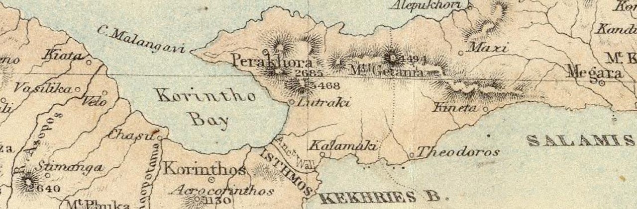
| Historical maps and photos of the Corinthia: These raster images are rubberheeted and georeferenced to modern control points in UTM, zone 34N. Each zipped file contains a TIF and a TFW world file. | ||||
 |
Francesco Morosini map of central Corinthia, 1687: 720Mb, Dated on Christmas day several months after his army made it's "fortunate shot" destroying the Ottoman powder magazine (the Parthenon) during the seige of Athens. It was drawn with south oriented to the top and split over six linen sheets. In this file it is reoriented north to the top and reassembled in one image before georeferencing. Ancient features, contemporary buildings and roads, fountains and springs, fortifications and towers, and topographic features are highlighted on this map. The area to the east of the Isthmus still has quite a bit of distortion. | |||
 |
Pierre Peytier map of Ancient Corinth, 1829: 122Mb, a small but accurate survey by the Morea Expedition shows that the lines of many roads in the village remain unchanged. | |||
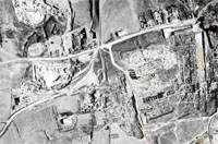 |
Aerial orthophoto of Ancient Corinth, 1932:17Mb. This is the first known aerial photo of the Archaeological site cataloged as negatives BW 3222 and BW 3223. Aerial photographs were ripped or cut into generally east-west strips, then assembled into a collage. The collage was then photographed onto two large format glass negatives one to the north and one to the south. The two negative scans were then overlaid into one image and georectified. | |||
Greece shapefiles with optional layer files: Coverage is the entire country or greater (various UTM). Sources and versions noted below. The layer files are optional, created by us, to enrich the visualization of the data.
- Ancient Place Names and Layer File (Pleiades): points, 6Mb. This modified version was translated from Pleiades original CSV to a shapefile.
- Ancient Theaters (geodata.gov.gr): 43 points, 4Kb. This ia a modified version in which Corinthian theaters were appended to the original file.
- Cities in English and Greek (geodata.gov.gr): points, 4Kb
- Cities in Greek (Geofabrik/OSM): points, 425Kb
- Coastline lines (Geofabrik/OSM); lines, 319Mb
- Coastline water polygon and Layer File (Geofabrik/OSM): polygons, 15Mb. For this modified version, we clipped the file to include the waters just beyond the borders of Greece.
- Modern administrative boundaries (geodata.gov.gr): Greece, line 8Mb; Kapodistrias plan 1997, polygon 6Mb; Kallikratis plan 2011, polygon 6Mb; Peripheries 2008, polygon 3.6Mb
- Natural Features like inland hydrology and forests with Layer File (Geofabrik/OSM): polygons, 12Mb
- Points of Interest (OSM): over 156,000 points in CSV format includes amenities, shops, historic, transportation, natural, etc.: edited file, 3.2Mb, and original 'flat' download, 3Mb. Geofabrik has convenient POI as well but the site far fewer points and less associated data.
- Railways and Layer File (Geofabrik/OSM): lines, 900Kb
- Roads and Layer File (Geofabrik/OSM): lines, 78Mb
- Rivers and Layer File (geodata.gov.gr): lines, 2Mb
- Settlements in English (geodata.gov.gr): points, 217Kb
- Urban Atlas cities (EEA): polygons, 185Mb, includes Athens, Thessaloniki, Patras, Iraklion, Larisa, Volos, Ioannina, Kavala, Kalamata (zones >100,000 pop.)
- Waterways and Layer File (Geofabrik/OSM): lines, 5Mb
- Corine Land Cover Inventory from 2000 and Layer File (geodata.gov.gr): polygons, 99Mb
Basemap, contours, and ASTER DEM: Coverage is 36-39 degrees latitude and 20-26 degrees longitude. ASTER GDEM is a product of METI and NASA. Bathymetry derived from EMODnet data
- Basemap.zip,118 Mb and BasemapWIthBathymetry.zip, 326 Mb: intended as a backdrop for the shapefiles on this page. The file is a zipped GeoTiff with a world file (.tfw) generated from the DEM below with naturally colored visualization (similar to the color maps at the top of the page) based on elevation, slope, and hillshade to provide a pleasant and informative background for other data. It retains the resolution of the original data which is nominally 1 arc-second or about 30 m per pixel, though actually less.
- Contour lines at 50 m interval and Layer File: lines generated from DEM, 15Mb
- The European Environment Agency also has some very nice 1 arcsec (~30m) base maps derived from SRTM and ASTER GDEM.
- BathymetryDEM.zip, 929 Mb, from EMODnet data.
*Note that the rivers and place name data may seem repetitive but each dataset has strengths and weaknesses.
*Greek names encoded with ISO 88597 and may not display properly in ArcGIS. Default encoding for ESRI must be set on Windows via "regedit" as per this ESRI support page.
Sources
The data are from the following:
- USGS Earth Explorer: a complete search and order tool for aerial photos, elevation data and satellite products distributed by the U.S. Geological Survey's Long Term Archive (LTA). The LTA at the National Center for Earth Resource Observations and Science in Sioux Falls, SD is one of the largest civilian remote sensing data archives. It contains a comprehensive record of the Earth's changing land surface including ASTER GDEM and SRTM.
- OpenStreetMap (OSM): Built by a cartographic community that contributes and maintains worldwide data about roads, trails, cafés, railway stations, and much more. © OpenStreetMap contributors (ODC Open Database License, Artibute/Share-Alike/Keep open). Geofapbrik.de (next entry below) probably has the most convenient up-to-date shapefiles, this OSM page has other sources, and QGIS has a great builtin function for querying and downloading data.
- Geofabrik: incorporated in late 2007 with the conviction that free geodata created by projects will become increasingly attractive for commercial uses. They provide regularly updated (new build each night) modern features and place names from Open Street Map data in Shapefile format. (ODC Open Database License, Attribute/Share-Alike/Keep open)
- NGA GEOnet Names Server: the official repository of standard spellings of all foreign geographic names, sanctioned by the United States Board on Geographic Names. The database also contains variant spellings (cross-references), which are useful for finding purposes, as well as non-Roman script spellings of many of these names. Toponymic information is based on the Geographic Names Database, containing official standard names approved by the United States Board on Geographic Names and maintained by the National Geospatial-Intelligence Agency. More information is available at the Products and Services link at www.nga.mil. The National Geospatial-Intelligence Agency name, initials, and seal are protected by 10 United States Code Section 425. (no licensing requirements or restrictions)
- geodata.gov.gr: designed, developed, and is maintained by the Institute for the Management of Information Systems of the "Athena" Research and Innovation Center in Information, Communication and Knowledge Technologies, with the aim to provide a focal point point for the aggregation, search, provision and portrayal of open public geospatial information. (Greek License Creative Commons Attribution, cc-by)
- European Environment Agency (EEA): an agency of the European Union, they provide sound, independent information on the environment. EEA standard re-use policy: unless otherwise indicated, re-use of content on the EEA website for commercial or non-commercial purposes is permitted free of charge, provided that the source is acknowledged (http://www.eea.europa.eu/legal/copyright).
- European Marine Observation and Data Network (EMODnet): provides services for discovery and requesting access to bathymetric data (survey data sets and composite DTMs) as managed by an increasing number of data providers. Data resolution since early February 2015 is 7.5 arc-second. To download, follow this link, click "download products", select a grid square, then select from a list of file formats (EMO, ASCII, GeoTif, NetCDF, SD, XYZ). If you need more, select another grid square, and repeat.
- Pleiades: gives scholars, students, and enthusiasts worldwide the ability to use, create, and share historical geographic information about the ancient world in digital form. At present, Pleiades has extensive coverage for the Greek and Roman world, and is expanding into Ancient Near Eastern, Byzantine, Celtic, and Early Medieval geography. Pleiades is a joint project of the Ancient World Mapping Center, the Stoa Consortium, and the Institute for the Study of the Ancient World. (Creative Commons License- cc-by)
More open data resources and information:
- Copernicus is the European Union's Earth Observation Programme, looking at our planet and its environment for the ultimate benefit of all European citizens. It offers information services based on satellite Earth Observation and in situ (non-space) data. Compared to ASTER GDEM and SRTM, Copernicus has higher resolution DEMs and other data for Europe and Greece.
- Digital Atlas of Roman and Medieval Civilization (DARMC): makes freely available on the internet the best available materials for a Geographic Information Systems (GIS) approach to mapping and spatial analysis of the Roman and medieval worlds. Geo-data offered covering topics such as climate, natural resources, settlements and harbors, artifacts, roads, shipwrecks, political boundaries, rats.(CC BY-NC-SA)
- ArchaeoStuff: a blog by Galician archaeologist, Emilio Rodríguez-Álvarez with a growing number of GIS tutorials using GRASS.
- Corinthian Matters: authored by ASCSA alumnus David Pettegrew, this blog is devoted to the archaeological and historical research of the modern region of the Corinthia. The "Maps" category is another source for similar images, contour datasets, and a tutorial for GIS software.
- Archaeology in (Geo)Space: Stories from one GIS-using-archaeologist to another: another excellent blog (unfortunately not live anymore) by an ASCSA member concerning GIS data, problems finding it, and using it in Greece. Check out the "Resources" page.
- Ancient World Mapping Center: an interdisciplinary research center at the University of North Carolina at Chapel Hill, it promotes cartography, historical geography, and geographic information science as essential disciplines within the field of ancient studies through innovative and collaborative research, teaching, and community outreach activities. Maps and gis data for ancient roads, names, aqueducts, and other ancient features (CC BY-NC).
- Archaeological Mapping Lab: originally established at the University of Pennsylvania Museum of Archaeology and Anthropology by Dr. David Gilman Romano, the Lab has relocated to its new home at the School of Anthropology, University of Arizona. Well published in paper document formats (JSTOR) but no electronic map files offered.
- freegisdata.org: Interesting links to various WMS servers and a page on Greece. Little is known about this site but here is a quote from the page, "Actually this is just a test. The idea is to provide an HTML user interface to a Free Gis Data CSW, organized by place and keyword."
- GeoCommons: the public community of GeoIQ users who are building an open repository of data and maps for the world. The GeoIQ platform includes a large number of features that empower you to easily access, visualize and analyze your data.
- GeoNames: geographical database covering all countries and contains over eight million placenames that are available for download free of charge.
- GSHHG: A Global Self-consistent, Hierarchical, High-resolution Geography Database. They have detailed coastline data.
- Digital Archive @ McMaster University Library: High resolution downloads of WWII Topographic maps with a collection of Greece at 1:100k. Thanks Dimitri Nakassis for the link!
- Natural Earth: public domain map dataset available at 1:10m, 1:50m, and 1:110 million scales. Featuring tightly integrated vector and raster data, with Natural Earth you can make a variety of visually pleasing, well-crafted maps with cartography or GIS software.
- Open Linked Data Greece: this page has very good information similar to Geodata.gov.gr
- datahub: a free, powerful data management platform from the Open Knowledge Foundation, based on the CKAN data management system.
- Socioeconomic Data and Applications Center (sedac): one of the Distributed Active Archive Centers (DAACs) in the Earth Observing System Data and Information System (EOSDIS) of the U.S. National Aeronautics and Space Administration. SEDAC focuses on human interactions in the environment. Interesting data including anthropogenic biomes of the world from 1700 CE to present.
- National Cadastre and Mapping Agency S.A.: their mission is the study, development, and operation of the Hellenic land registry. They offer a Web Mapping Service server basemap for Greece that is more accurate than Google Earth. Add the following link (http://gis.ktimanet.gr/wms/wmsopen/wmsserver.aspx) to an Image Overlay in Google Earth or in ArcGIS, Add Data>Look in:GIS Servers>Add WMS Server>URL. For guidance adding the WMS server, see these links for Google Earth and ArcGIS.
Layer Files, how to...
Layer files (.lyr) contain information on the color and symbols used to visualize the data. They are included here to save time assembling an attractive map. In ArcGIS first add the shapefile or raster data, then right click>Layer Properties>Symbology Tab>Import>Browse button and browse for the .lyr that corresponds to the data. Alternately try a Google search for "import symbology from layer file."
Errors
The data on this page are gathered and presented in good faith. For the information from outside sources, we assume no responsibility for errors or consistency in transliteration. Pleiades and Geofabrik/OSM are community driven projects with regularly updated data. Visit the sites to download updates or join the sites to create and edit data yourself. For errors in the Corinth archaeological data, please contact James Herbst.