Maps of the Mediterranean
Search the map collection of the Gennadius Library
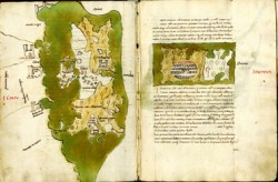
The Gennadius Library is a repository of an outstanding collection of about 3,000 historical maps on Greece, the Balkans and Turkey, an important part of the collection of Joannes Gennadius. Spanning a period from the late fifteenth to the twentieth centuries, these maps are either drawn in hand or were printed by noted cartographers and map publishers. Some highlights include: a series of island maps in the Ionian and Aegean seas from a fifteenth century manuscript of Buondelmonti’s Liber Insularum, an early nineteenth century chart of the Aegean by Nicolas Kefalas (possibly the first printed Greek nautical chart), and numerous maps concerned with the political development of the Balkan states in the late nineteenth century.
The project Mapping Mediterranean Lands, conducted under the aegis of the Council of American Overseas Research Centers, created a fully searchable web-based catalog of significant early and unique maps of the Mediterranean region accompanied by information drawn from archives, manuscripts, and early printed books at eight American overseas research centers.
The valuable cartographic material of the Gennadius Library was catalogued by Leonora Navari and Alexis Malliaris under the wise leadership of Catherine DeG. Vanderpool and Natalia Vogeikoff-Brogan (MedMaps project completed in 2004). Part of the material was photographed by Arthur and Jennifer Stephens, and the rest was digitized in 2011-2014 thanks to the ESPA grant “Digital Access to the Gennadius Library.” We are grateful to Panagiotis Valourdos for processing the metadata and to Tarek Elemam for the online presentation.