Map Collection
COLLECTION OVERVIEW - ΕΠΙΣΚΟΠΗΣΗ ΣΥΛΛΟΓΗΣ
Collection Number: GR ASCSA MAP 115
Name(s) of Creator(s): American School of Classical Studies at Athens
Title: Map Collection
Date [bulk]: 1900-1945
Date [inclusive]:
Language(s): Greek, English
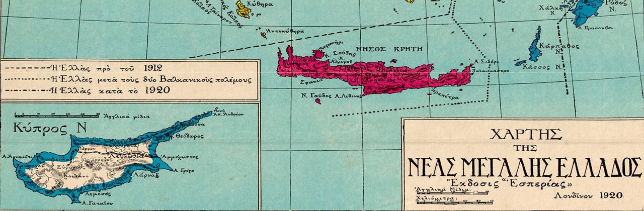
Summary: The collection consists of about 568 maps of Greece of various scales, publishing agents and dates (e.g. Χαρτογραφική Υπηρεσία Στρατού/Hellenic Army Cartographic Service, later known as Γεωγραφική Υπηρεσία Στρατού, maps of the Royal Engineers of the British Army dated to 1943-1944, maps of the Εθνική Στατιστική Υπηρεσία της Ελλάδος), supplemented by maps of Cyprus, Turkey-Asia Minor, Albania, former Yugoslavia and Bulgaria, as well as general maps of the Balkan Peninsula. The map collection was initially housed in the Eugene Vanderpool Drafting Room of the Blegen Library and was moved to the ASCSA Archives in 2018.
Quantity: 568 items
Immediate Source of Acquisition: Blegen Library, 2018
Information about Access: The collection is available for research.
Cite as: American School of Classical Studies at Athens, Archives, Map Collection (Αμερικανική Σχολή Κλασικών Σπουδών στην Αθήνα, Map Collection)
For more information, please contact the Archives at:
The American School of Classical Studies at Athens
54 Souidias Street, Athens 106 76, Greece
phone: +30 213 000 2400 (ext. 425)
Contact via E-mail
SCOPE AND CONTENT
Over the years, an important browsing collection of maps was put together in the Blegen Library. Most of the maps were purchased for the needs of scholars, though some series must have belonged to members of the School. At least two maps are identified as B.H. Hill’s; one of Kerkyra (dated 18/7/1921) from when he was travelling with Hetty Goldman in search of a site to excavate before settling on Colophon in Asia Minor; and the other of Aisymi on the northern borders of Greece from when he was in the service of the American Red Cross Commission to Greece.
The map collection was initially housed in the Eugene Vanderpool Drafting Room of the Blegen Library and was moved to the ASCSA Archives in 2018. The collection consists of about 568 maps of Greece of various scales, publishing agents and dates (e.g. Χαρτογραφική Υπηρεσία Στρατού/Hellenic Army Cartographic Service, later known as Γεωγραφική Υπηρεσία Στρατού, maps of the Royal Engineers of the British Army dated to 1943-1944, maps of the Εθνική Στατιστική Υπηρεσία της Ελλάδος), supplemented by maps of Cyprus, Turkey-Asia Minor, Albania, former Yugoslavia and Bulgaria, as well as general maps of the Balkan Peninsula.
Of particular interest are historical maps such as the series Χάρτης Ελληνικού Βασιλείου, 1908-1912 (Β. Παπαχρύσανθος), 1:75,000, showing areas of Greece that were not yet part of the state and the British War Office Maps, 1941-1945. The latter are valuable not only for their precision and mapping accuracy since they were drawn from aerial photographs, but also as historical documents of the era of World War II. All maps are extremely useful for those interested in toponyms, since they preserve old names of places. Among the few town plans, the plan of Athens Τοπογραφικός και Υψομετρικός Χάρτης Αθηνών (Γλένης 1914) and the plan of Thessalonike before the great fire (Salonica, War Office, March 1909) have added research value.
All geological & metallographical maps by ΙΓΜΕ (ca 108 maps), as well as an almost complete series of 1:50,000 Greek Army (ΓΥΣ) maps of Greece (ca. 240 maps), were transferred to the Wiener Lab.
Leda Costaki
January 2019
INVENTORY
For an inventory of the map collection, see here